Address: Tērvete, Dobele, Auce County
Tērvete Castle mound - Klosterkalns - Zviedru kalns - Dobele Castle mound - Spārnu Castle mound - Ezerlūķi Castle mound - Incēni Castle mound - Mežakalns


Address: Tērvete, Dobele, Auce County
Tērvete Castle mound - Klosterkalns - Zviedru kalns - Dobele Castle mound - Spārnu Castle mound - Ezerlūķi Castle mound - Incēni Castle mound - Mežakalns
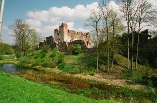
The castle mound of Dobele is situated on the right bank of the river Bērze not far from the crossing of the motor road of Bauska and Saldus. Today the most attractive place of interest for visitors is the ruins of the stone castle built in 13th - 16th centuries that was constructed instead of the burnt timber castle of the Semigalians. In the east and the north from the riverside the castle mound is of 20 - 25 m height, in the west - comparatively lower with trenches that protected it.
In written sources the name of Dobele was first mentioned in the Bisection agreement of Zemgale in 1254. Several times the name of Dobele was mentioned in the Rhyme Chronicle when informing about the battles of the 13th century.
Archaeological research made in 80ies of the 20th century when found antiquities allowed stating that Dobele had been inhabited place already B.C. The antiquities characteristic for 14 - 16th centuries werw found in the forepart of the castle - the arrowhead of a bow, a spur, spearhead, working tools, household objects and trinkets. Part of findings relates to the inhabitation of the castle in later periods.
Information and guide services: + 371 63721309
The castle mound of Ezerlūķi is situated in the eastern bank of the lake Zebrus about 300 m from the dwelling Ezerlūķi
The castle mound of approximately 30 m height is separately standing hillock in the middle of the field that is patially overgrown with trees ; the oval plateau of the area of 1125 m². The slope at the western riverside of the hill is very steep, opposite slope flatly passes to surrounding fields.
The inhabitants of the dwelling Ezerlūķi informed that previously the road made of limestone (dolomite) lead from the island of the river Zebrus to the castle mound. Today one can only guess what is hiding under the mirror of the river because neither island, nor the road can be seen anymore.
Information: +371 26136682.
Spārnu kalns is situated on pictureque southeastern banks of the lake Spārni near the outlet of the river Sesava. The castle mound is about 30 m high and unusually steep, of elongated form with the dam of 2 m height at the northerly part. The place of the ancient town is found to the west of the castle mound. The odds are that the castle mound of Spārni had been castrum Sparnene, the centre of Spārnene lands.
Archaelogically the castle mound was surveyed in 60ies of the 20th century. Several antiquities were found - wheel made pottery, silver horseshoe - fibula, silver sticks, bronze pendant.
Information: +371 26136682.
Mežakalns is situated not far from Kokmuiža on the left bank of the river Avīkne opposite to the castle mound of Incēni. The castle mound is grown with thick deciduous forest, mainly the oak forest; therefore it is difficult to see it.
The 2 km peaks of os hillocks of Dobe hills form the castle mound of Mežakalns and Incēni, they are separated by glen of the river Avīkne and the road from Kokmuiža to Lielauce. Separation of the trenches and dams from the other hill, has artificially formed Mežakalns. Main dam is 10 m high; another is only 4 m high. The plateau occupies the area of 4200 m².
It is possible that Doben, the castle of Dobe, mentioned in the Oldest Rhyme Chronicle, constructed by the Livonia order in 1260, had been situated in Mežakalns.
Information: +371 26136682
The castle mound of Incēni is situated not far from Kokmuiža on the right bank of the river Avīkne. The castle mound has been laid out by artificially banking and making the castle mound of almost quadrangular form with well trimmed and unusually steep sides in the southern part in the height of about 7 m. The ancient town has been found in the eastern part that is proved by the thick archeological layer with findings of chippings and antiquities. In written sources the castle mound was first mentioned in the Bisection agreement of Zemgale in 1272. The odds are that the castle mound of Incēni (Dobe) has been the ancient centre of the castle region and the main fortification of Dobe.
Earnest Brastin investigated the castle mound 1923. He was sure that the castle of Sidrabene had been situated there.
Information: +371 26460612 .
Zviedru kalns is situated on the right bank of the little river Tērvete, 200 m to the north west from the castle mound on two hills of 10 - 12 m that have been separated by deep ravine. The archaeologist A. Gusar has set a hypothesis that there were an artificial water head between Zviedru kalns and the castle mound of Tērvete. The eastern part of the castle mound has been fortified with a trench of 7 m and a fortification head.
Zviedru kalns is also called Svētkalns has been mentioned in the Rhyme Chronicle. At the end of the 13th century the Order built Hellingenberg, the castle of Svētkalns near to Tērvete that served as the location place for the troop of 300 men and there the attacks to the Semigalians were constantly made. The castle survived not long because after the inhabitants of Tērvete had moved to the Rakte Order, the Master required taking it down.
Another name of the castle mound "Zviedru kalns (Swedish Hill) is related to 1701 when tHe Swedish King Carl XII attacked the castle of Kalnamuiža from Svētkalns during the Great Northern War.
Archeologically the castle mound was recurrently investigated starting with research of August Bealenshtein made in 1866.
Information: +371 26738535.
Klosterkalns is situated on the left bank of the little river Tērvete about 100m to the South of the castle mound of Tērvete near to highway Dobele - Bauska. The hill is overgrown with a thin coniferous and deciduous forest and its shapes can be only partially guessed.
Klosterkalns had been inhabited since 1st century B. C. till the beginning of A. D. It had been fortified with two parallel walls of horizontal beams. There were the hearts at the edge of the plateau.
Archeologically Klosterkalns was investigated in 70ies of the 20th century. Archaeological layer and found antiquities prove that the castle mound was inhabited, as well as about the way of living of the population - the ancestors of ancient Semigalians, cattle breeding initially was the main occupation, later - agriculture.
Information: + 371 26738535.
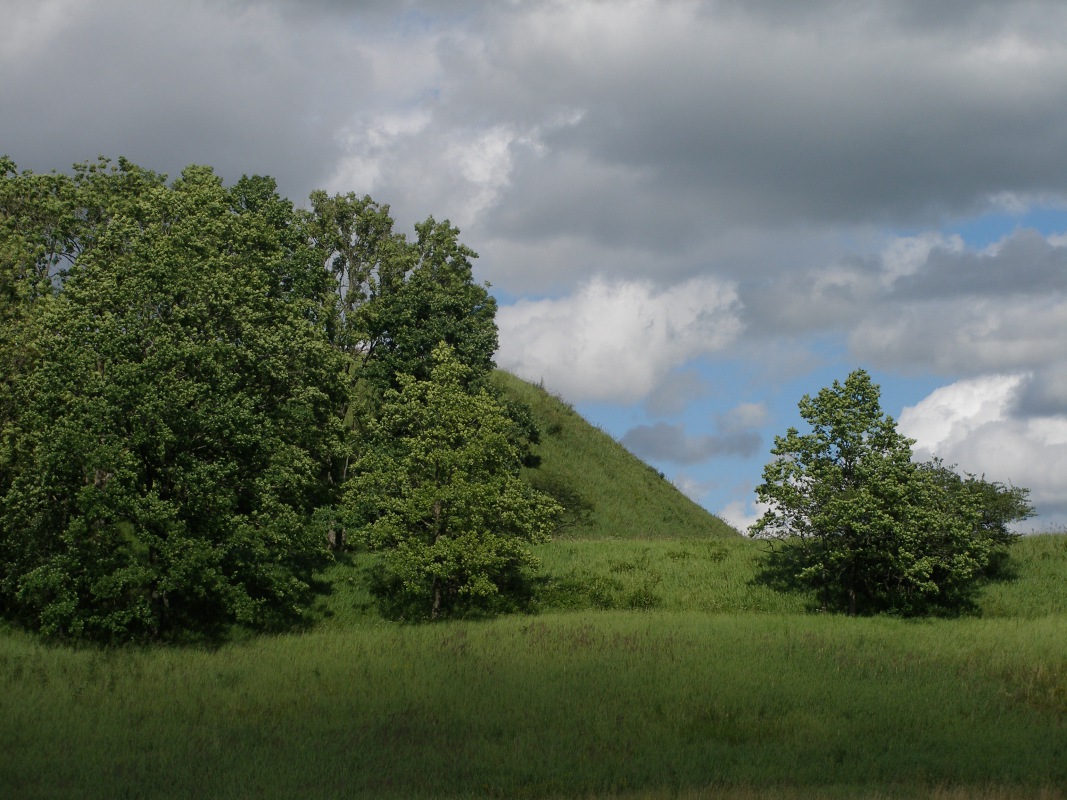
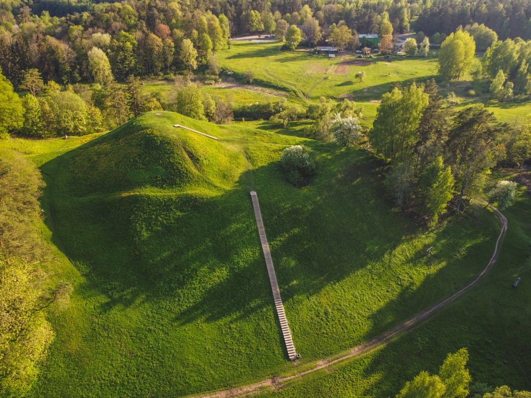
The castle mound of Tērvete is situated on the right bank of the little river Tērvete on the hill of 19 m that has been artificially arranged in plateaus of a castle and forepart of a castle. Around the castle mound in the West there had been the ancient town in the area of 9,5 ha.
The castle mound of Tērvete is one of the most impressive and most prominent not only in the western Semegalia, but also in ancient Baltic areas. The Chronicle of the Henry and the oldest Rhyme Chronicle notify about Tērvete where the timber castle, the dwelling of a ruler and two foreparts of castles of Tērvete castle region, and also the rulers of the 13th centuries - Viestards and Nameisis have been mentioned. Tērvete has been the centre of western Semigalia where fierce battles took place between the Semigalians and the troops of Livonia Order in the 13th century. Till 1286 the Semigalians have burnt the castle of Tērvete and removed to the castle mound of Rakte in Lithuania.
Information: +371 26738535.